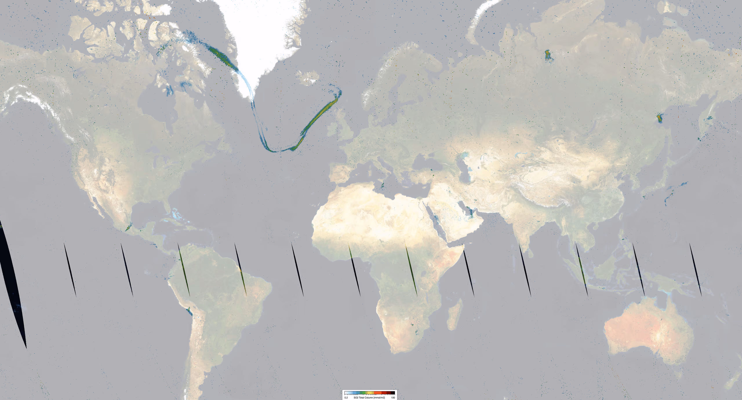
Sulfur dioxide (SO2) enters the Earth's atmosphere through both natural sources (~30%) and anthropogenic processes (~70%). It plays a significant role in atmospheric chemistry on both local and global scales, with impacts ranging from short-term pollution events to long-term climate effects. Monitoring SO2 is vital for tracking industrial emissions and detecting volcanic activity, which poses a specific risk to aviation safety alongside volcanic ash.
Key Features and Applications
The TROPOMI SO2 product is essential for the identification of enhanced SO2 levels, allowing for the real-time detection and monitoring of volcanic eruptions and anthropogenic pollution sources. By providing high-resolution global data, the product supports air quality assessment and disaster mitigation efforts. To ensure operational utility, the data is typically made available in near-real-time, within approximately three hours of measurement.
Dataset Specifications
Examples of filenames (a.k.a. granules):
S5P_OFFL_L2__SO2____20260201T231910_20260202T010040_43039_03_020800_20260203T215211.nc S5P_NRTI_L2__SO2____20260201T234313_20260201T234813_43039_03_020800_20260202T005414.nc S5P_RPRO_L2__SO2____20220701T230527_20220702T004657_24439_03_020401_20230315T012451.nc |
|
Elements in the filename separated by underscores after the initial "S5P": |
Dataset Specifications V2 | |
| Temporal Coverage |
Since 12-Jul-2020 Reprocessed (RPRO) dataset: from 30-Apr-2018 to 03-Aug-2022 |
| Spatial Coverage |
~2600 km swath Full daily surface coverage of radiance and reflectance measurements for latitudes > 7° and < -7°, and better than 95 % coverage for latitudes in the interval [-7°, 7°] |
| Spatial Resolution at Nadir |
3.5 x 7.0 km (across x along track), at beginning of mission 3.5 x 5.5 km (across x along track), since 6 August 2019 |
| Processor Version | 02.xx.xx, with x=any digit between 0 and 9 |
Dataset Specifications V1 | |
| Temporal Coverage |
From 30-Apr-2018 to 12-Jul-2020 |
| Spatial Coverage |
~2600 km swath Full daily surface coverage of radiance and reflectance measurements for latitudes > 7° and < -7°, and better than 95 % coverage for latitudes in the interval [-7°, 7°] |
| Spatial Resolution at Nadir |
3.5 x 7.0 km (across x along track), at beginning of mission 3.5 x 5.5 km (across x along track), since 6 August 2019 |
| Processor Version | 01.xx.xx, with x=any digit between 0 and 9 |
How to Access the Data
The data related to this product and to the other S5P/TROPOMI products are accessible via the Copernicus Data Space Ecosystem (CDSE).
Documentation and Related Datasets
Technical documentation on the S5P/TROPOMI Level-1B and Level-2 products can be found on the the SentiWiki S5P Products page.
Dataset Citation Guidelines
Users, who, in their research, use ESA Earth Observation data that have been assigned a DOI, are asked to use it when citing the data source in their publications:
Dataset Citation Guidelines V2 |
| Copernicus Sentinel-5P (processed by ESA), 2020, TROPOMI Level 2 Sulfur Dioxide Total Column products. Version 02. European Space Agency. https://doi.org/10.5270/S5P-74eidii |
Dataset Citation Guidelines V1 |
| Copernicus Sentinel-5P (processed by ESA), 2018, TROPOMI Level 2 Sulfur Dioxide Total Column products. Version 01. European Space Agency. https://doi.org/10.5270/S5P-yr8kdpp |